Where eagles dare
środa, 8 października 2008
Miejscowość Gangotri 3048 mnpm, położona we wspaniałych Górach Garhwalu w najbardziej wysuniętej na północ części Uttar Pradeshu, blisko granicy z Tybetem. Lato jest tu względnie chłodne, zima niewyobrażalnie mroźna a wiosna deszczowa. Bramy świątynii dla wiernych i turystów otwarte są od maja do listopada. Dziś zamieszczamy tekst o wyprawie trekkingowej w formule "tylko dla orłów"...Na razie w wersji oryginalnej.(ac)
The temperature was minus 30Celsius and the trakkers hip dep in snow... It was an adventure of lifetime. The year 2002 was the International year of the Mountain, when members of Science and Adventure Club, Trichy had climbed Jogin-III, 20,060 ft. in the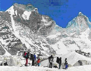 Garhwal Himalaya. Obrazek We had prepared for a year for the expedition. Everyday we carried a rucksack weighing 10 kg and walked five km. We exercised for more than an hour — yoga, cycling, walking up and down the steps of the gallery in the Stadium. The territories of Garhwal and Mumaon, referred to as Kedar Khand in the scriptures extend from the Tons River watershed in the West to the Kali Ganga in the East. It comprises of eight districts: Tehri Garhwal, Pauri Garhwal, Dehradun, Chamoli, Uttarkashi, Pithoragarh, Nainital and Almora. The first five belong to Garhwal proper, while the last three to Kumaon. Uttarkhand is now popularly known as Uttaranchal, with Himachal Pradesh in the West, Nepal in the East, the plains of Uttar Pradesh in the South, and Tibet in the North. Ganga and Yamuna originate from the snowy slopes of Garhwal. Every village, river, valley and mountain has a story behind it. We followed the river Ganga on our journey from Haridwar to Gangothri. It is from here that the river surges ahead to begin the long journey over the Indian plains. Sometimes the river flows close to the road and at other times we can hear the rush and the roar of the river far below in the deep and narrow gorges. The pines and deodar on the mountain slopes on either side of the meandering Ganga were beautiful to behold. Uttarkashi is a fairly large town situated on the right bank of Baghirathi river, 144 km north of Rishikesh. The Nehru Institute of Mountaineering is located here.. We had erected our tents on the outskirts of Gangothri (9,800 ft.). On the way to Gangothri, at Bhairon Ghati, glimpses of Brighu mountain range, Sudarshan peak, Matri and Cheedvasa Peaks form part of the landscape. It is from Bhairon Ghati, through Jat Ganga that the famous German mountaineer Henrich Harrier escaped to Tibet, became the teacher for the Dalai Lama and wrote the classic Seven Years in Tibet. Gangothri is a small hamlet on the banks of the Bhagirathi Ganga. On May 13, 2002, we started our trek to Bhoj Kharak. The trail lies just across the Bhagirathi river and runs east of
 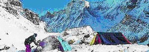 Gangothri. We pass through pine and birch forests, the path is treacherous — one careless step and we could land in the river 1000 ft. below. After an exhausting eight km. trek we are welcomed by a beautiful meadow in Bhoj Kharak (12,200 ft.), our campsite. We can see the snow covered tops of Manda and Hanuman Tikri from here. Our next campsite was at a height of 14,000 ft. at Kedar Kharak. It is a flat meadow from where the peaks of Manda (21,600 ft.), Brighu Panth (21,900 ft.), and Thalai Sagar (22,300 ft.) can be seen. The following day we were at the lake-Kedar Thal at a height of 16,000 ft. Obrazek The multiple peaks of Manda, Brighupanth, Jogin II and Thalai Sagar painted the landscape on one side. The Jogin glacier and the hanging ice, fall breaking into small glacier pools at the bottom of these awesome peaks. The temperature fell to -30° C, the kitchen tent collapsed and all the kerosene spilt. We wore our Koflach climbing boots (boots made of fibre glass) and crampons (spikes attached to the boots) and got out of our tents. The rarified air and the relentlessly cold sleepless night had made us weak. Our attempts to get any higher was not possible because we were sinking hip deep in the freshly fallen snow. We were disappointed at not being able to get to our destination — the summit of Jogin III. In the pursuit of adventure, man stretches his limits. We had done just that. We wanted to reach the summit of Jogin III but the natural elements had their own way of not allowing us into their territory.
J Ramanan was the leader - Jogin III Expedition May 2002.